Wildfire Plans & Maps
Community Wildfire Protection Plans
-

CWPP Status and Meeting Sign-up
Join us at the table for wildfire learning and risk-reduction action for your region!
-

CWPP Overview Sheet
Empower communities with CWPPs: Vital for federal funding & wildfire protection. Prioritize safety, resources, and action.
-
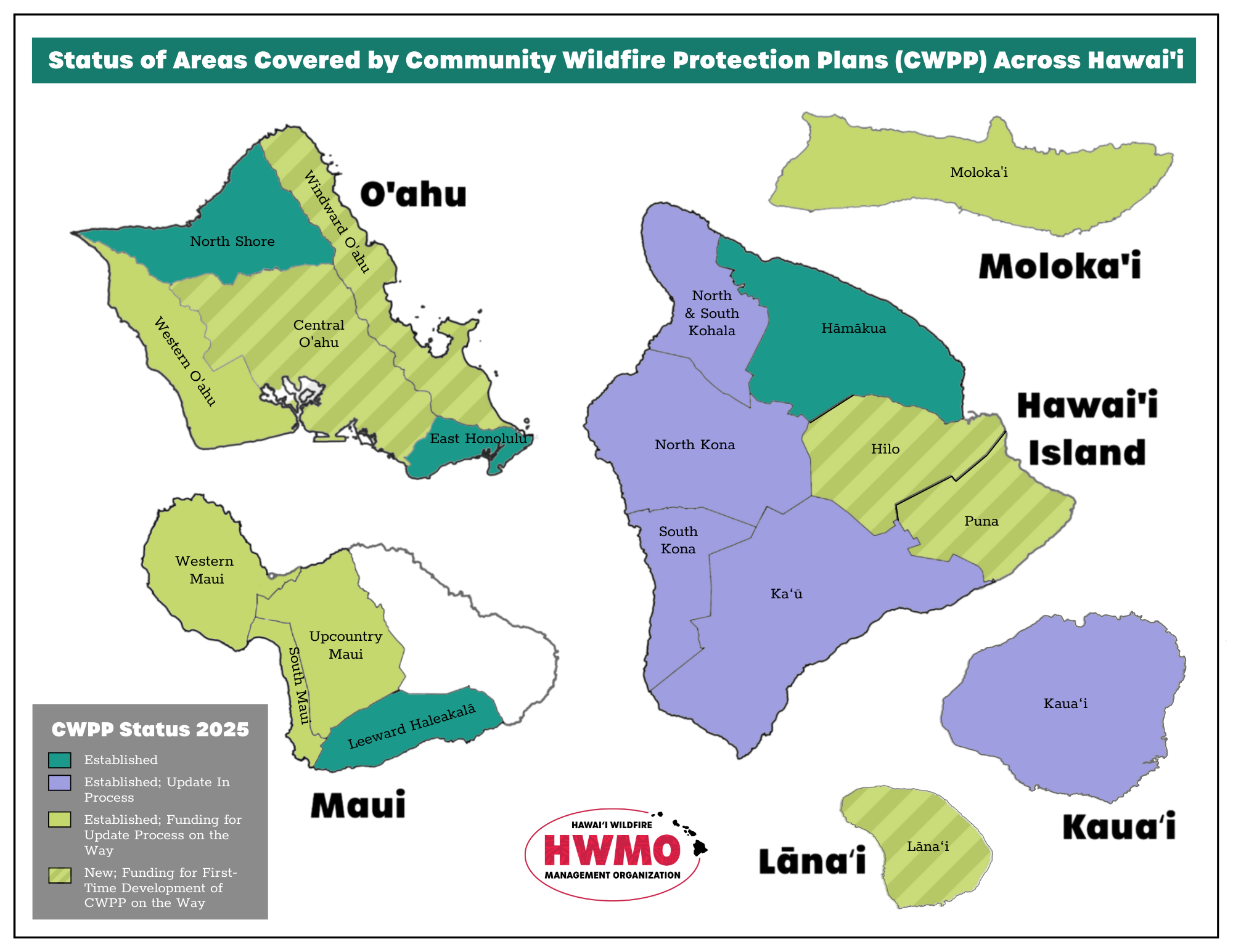
CWPP State Coverage Map
Discover CWPP State Map: Assess wildfire risk across Hawaiʻi!
-

Kaʻū CWPP - Updated 2024
Explore the updated Kau CWPP for current wildfire protection measures and strategies.
-

Northwest Hawaiʻi Island CWPP - Updated 2024
Discover updated wildfire protection strategies in the Northwest Hawaiʻi Island CWPP.
-

Hāmākua CWPP - Updated 2024
Explore the Hāmākua CWPP for effective wildfire mitigation strategies and community resilience.
-

North Kona CWPP - Updated 2024
Discover the North Kona CWPP, a roadmap for wildfire resilience in the region.
-

South Kona CWPP - Updated 2024
Delve into the revised South Kona CWPP for crucial wildfire readiness details.
-

Upcountry Maui CWPP - Updated 2024
Discover Upcountry Maui CWPP, a strategic blueprint for wildfire resilience.
-

Leeward Haleakala CWPP - Updated 2024
Explore the Leeward Haleakala CWPP for comprehensive wildfire protection strategies.
-

South Maui CWPP - Updated 2024
Explore the South Maui CWPP for effective wildfire mitigation strategies and community resilience.
-

Western Maui CWPP - Updated 2024
Discover strategies outlined in the Western Maui CWPP for effective wildfire mitigation.
-

North Shore Oʻahu CWPP - Updated 2024
Discover the North Shore Oahu CWPP for effective wildfire mitigation strategies.
-

East Honolulu CWPP - Updated 2024
Explore the East Honolulu CWPP for effective wildfire mitigation strategies and community resilience.
-

Western Oʻahu CWPP - Updated 2024
Discover the Western Oahu CWPP, a blueprint for wildfire resilience in the region.
-
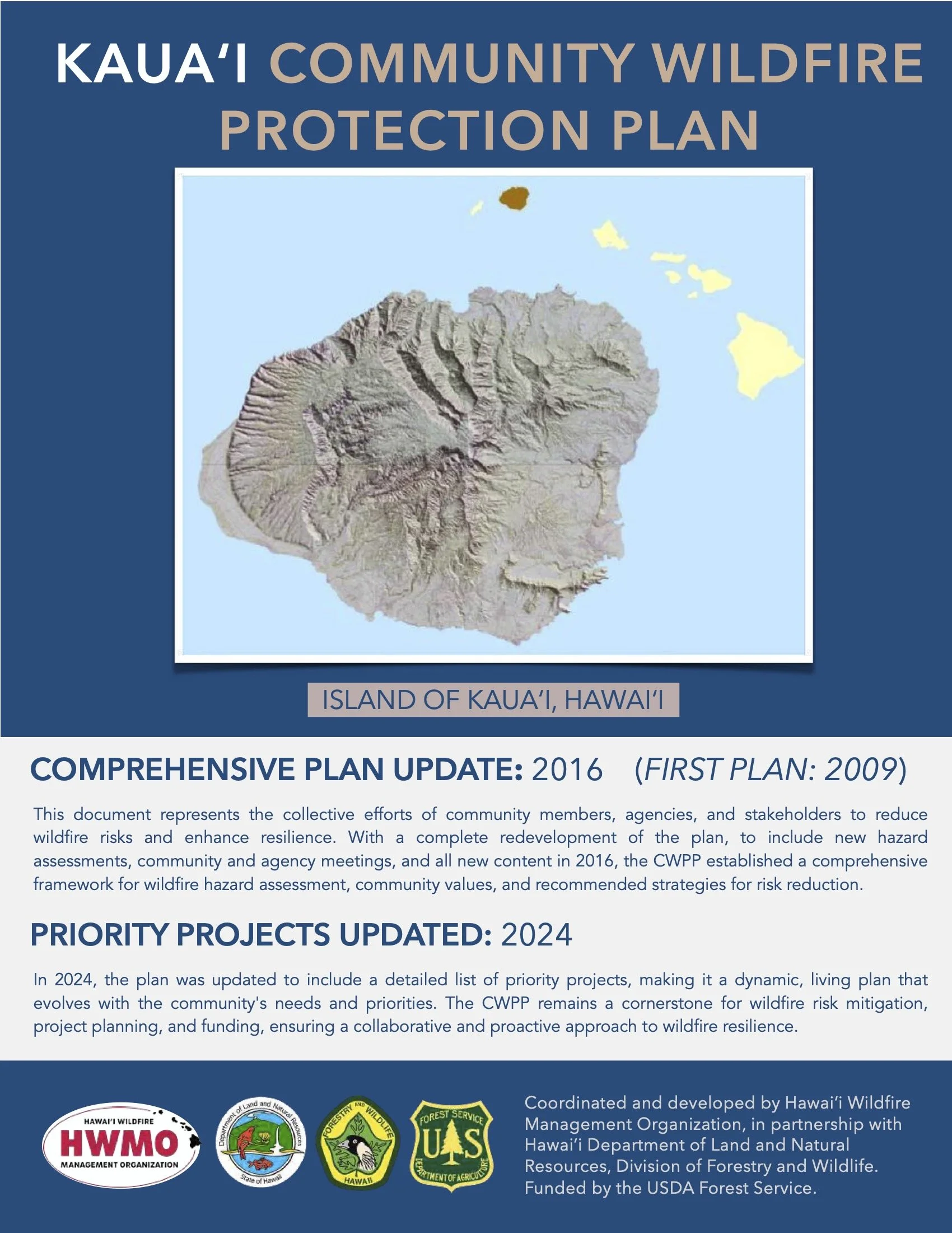
Kauaʻi CWPP - Updated 2024
Explore the updated Kauaʻi CWPP for enhanced wildfire preparedness measures.
-

Molokaʻi CWPP - Updated 2024
Discover the Molokai CWPP for effective wildfire mitigation strategies.
Fire History Maps
-

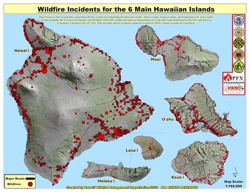
State of Hawaiʻi Wildfire History Map (1999-2022)
Updated wildfire incident map (1999-2022) compiled by HWMO from federal, state, and local agencies' data
-
State of Hawaiʻi Wildfire History Map (2002-2012)
USFS funded HWMO to gather fire data, collaborating with UH. Records were meticulously compiled and geo-located.
Vegetation Mapping and Results

Community Wildfire Hazard Assessments
-

Central Maui
-

East Hawaiʻi Island
-

East Maui
-

Kauaʻi
-

Lānaʻi
-

Molokaʻi
-

North Hawaiʻi Island
-

Southwest Hawaiʻi Island
-

West Maui
Communities at Risk of Wildfires
Updated Communities at Risk (CAR) Maps Available Spring 2026
The Communities at Risk (CAR) maps offer a statewide view of wildfire hazard levels for communities in Hawaii. They are a foundational resource for preparedness planning and for prioritizing mitigation and resilience efforts. Many communities face elevated wildfire risk due to factors such as unmitigated fuels, limited water and firefighting capacity, gaps in community engagement, and unmet needs in pre and post fire planning.
In support of its mission to protect communities and natural resources, HWMO has conducted hazard assessments for every community in the state. Updated assessments and maps are currently in development and will provide a more accurate and comprehensive understanding of wildfire hazards for communities, decision makers, fire responders, and natural resource managers.
-

Communities at Risk - All Hawaiian Islands 2014
-

Oʻahu CAR - 2014
-

Kauaʻi CAR - 2014
-

Maui CAR - 2014
-

Lānaʻi CAR - 2014
-

Molokaʻi CAR - 2014
-

Hawaiʻi Island CAR - 2014
Kawaihae Wildfire Plan
The Greater Kawaihae Wildfire Plan provides a comprehensive framework to improve wildfire readiness, safety, and recovery for communities, landscapes, and emergency response agencies in the region.
Developed through collaboration between landowners, government agencies, and community partners, the plan outlines goals and priority actions for before, during, and after wildfire events.
Its purpose is to guide coordinated efforts that protect lives, homes, natural resources, and nearshore waters while building long-term resilience across the Greater Kawaihae region.
